

Take Action: Klamath River Runs Brown!
- EPIC Staff
- Jul 21, 2015
- 11 min read
Updated: Aug 30, 2023

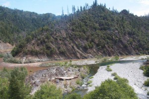
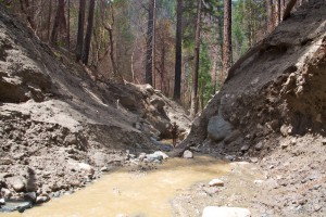
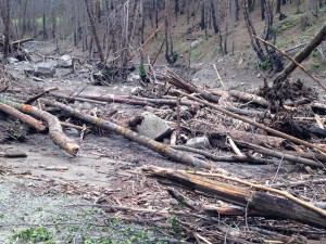
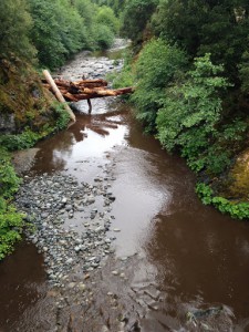
Take Action Now to stop Westside: A few short but intense rain storms hit the 2014 fire areas on the Klamath National Forest causing massive sediment events that turned the mighty Klamath and Salmon River systems muddy and brown. On July 5th, 7th and 12th rainstorms brought over an inch of rain in less than an hour causing road damage, intense debris torrents with slurries of mud, rock, water and trees to sliding for miles, filling in pools and creeks that serve as some of the best salmon spawning habitat. These watersheds are located within the same steep and unstable hillsides that are targeted for logging in the Westside Project.
Salmon
Juvenile and adult salmon struggle to survive in oxygen-depleted lethal water temperatures with high rates of disease and algae. The storm events greatly increased turbidity and lowered oxygen levels in the water for nearly two weeks. Massive amounts of sediment dumped into some of the most important spawning habitat and cool water refuges. There appears to be considerable reduction in size, volume, and depth of pools. It is uncertain how salmon and other aquatic life will survive this onslaught of impacts, especially with the hottest summer temperatures soon to come and the proposed clearcutting and logging activities.
Coho salmon are listed as threatened under the Endangered Species Act. There are 101 miles of coho Critical Habitat in the project area. This includes the rivers affected by recent storms, Klamath and North Fork Salmon Rivers and many of the cool water tributaries vital for fish survival, including: Grider, Beaver, Elk, South Russian Creeks and Whites Gulch.
Roads
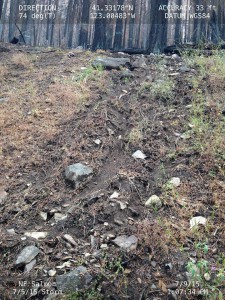
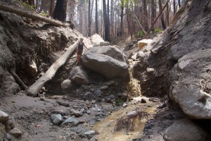
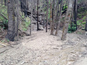
Road systems were blocked and sliding mud, trees, rock and debris clogged dozens of culverts and ditches. Thousands of cubic yards of sediment came down hills and hundreds have already been cleared from roads with heavy machinery, but much more debris continues to be suspended on the hillsides waiting for the next rain event.
Click here for before and after photos of road work in the Walker Creek drainage. At least 24 different road locations on roads 46N64, 46N65, and 46N67 were blocked by mud, rock, and debris flows, and numerous culvert inlets are still buried under mud and rocks.
Roads are the leading contributor of sediment into our creeks and rivers. There are over 950 “legacy” sites, which are chronic sources of sediment in the Westside project area. The Klamath National Forest is proposing to treat only 150 legacy sites in one watershed, leaving over 800 sites untreated.
The Forest Service proposes to open miles of decommissioned and self-decommissioned roads. These roads also contain legacy sites. For instance, road 16N41 up Little Elk Creek is approximately 2 miles long and completely grown over, which would require intense forest clearing and reconstruction just upstream of coho Critical Habitat. Further, there are over 280 miles of level 2 roads, passable by high clearance vehicles only, which would require reconstruction in order to accommodate for the proposed use by heavy machinery and large trucks. These are few of many road issues that were not adequately considered, addressed or disclosed.
The Past the Future and Westside
As temperatures and extinction rates soar globally and climate change brings more extreme weather, like summer rainstorms – our water, wildlife, salmon and wild places need extra protection. Low to no snow pack and higher temperatures means increasingly low and warm summer flows in our rivers. Extreme wind, rain and fire leave behind fragile ecosystems susceptible to severe damage from industrial activities on the landscape.
The Klamath Mountains are some of the steepest and most erodible hillsides on the west coast. For decades we have witnessed and documented major impacts to our watersheds during large storm events. The decomposed granitic soils in the Westside fire areas will slide downhill and into our rivers. The entire watersheds of Grider and Walker are unstable, which is where the highest concentration of Westside units are proposed!
Rivers and Creeks up Close
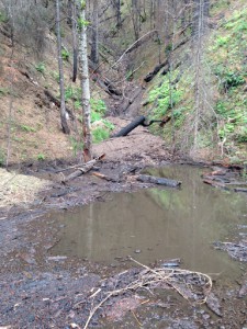
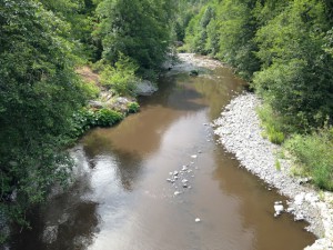
A few short and intense summer storms brought massive debris flows choking the Klamath and Salmon Rivers and many of its tributaries with thick sediment and mud. The Klamath Mountains are some of the steepest and most erodible lands on the west coast. The rivers listed below support a suffering salmon population- all are proposed for clearcut logging by the Klamath National Forest in the Westside project and all are listed as impaired under the Clean Water Act, mostly from temperature and sediment. Many of them are supposed to be federally protected designated or eligible for designation as Wild and Scenic Rivers.
Klamath River
The Wild and Scenic Klamath River (Karuk: Ishkêesh, Klamath: Koke, Yurok: Hehlkeek ‘We-Roy, Hupa: k’ina’-tahxw-hun’) flows 263 miles southwest from Oregon and northern California, cutting through the Cascade Range to empty into the Pacific Ocean. It is listed as impaired under the Clean Water Act for Nutrients, Organic Enrichment/Low Dissolved Oxygen, Temperature and Microcystin.
It was once the third most productive salmon-bearing river system in the country. Today, thanks to habitat blocking dams, logging, mining, grazing, agriculture, poor water quality and too little water left in the river, the once abundant Klamath salmon runs have now been reduced to less than 10% of their historic size. Anadromous species present in the Klamath River basin below Iron Gate Dam include Chinook, coho, pink, and chum salmon, steelhead and coastal cutthroat trout, eulachon, white and green sturgeon, and Pacific lamprey. Some species, such as coho salmon, are now in such low numbers in the Klamath River that they are listed under the Federal Endangered Species Act (ESA).

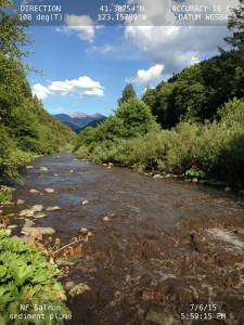
North Fork Salmon River
Deeply incised canyons, rugged terrain and highly erodible soils characterize the Salmon River watershed, comprised of two forks, the North Fork and the South Fork to form the mainstem. The free flowing river is one of the largest most pristine watersheds in the Klamath River system, although it is listed under the Clean Water Act as a 303(d) impaired water body for high temperatures. The Wild and Scenic Salmon River provides over 175 miles of anadromous fish habitat and retains the only viable population of spring Chinook salmon and retains the last completely wild salmon and steelhead runs in the in the Klamath watershed. The Salmon River offers some of the best habitat on the west coast for salmon, steelhead, green sturgeon, rainbow trout, Pacific lamprey, and other fish. It is home to one of the most sought after world-class whitewater rafting trips in the country. It combines lush coastal scenery with emerald green waters, steep granite gorges and numerous waterfalls.
The North Fork Salmon River, containing highly erodible granitic soils is steep to very steep. The globally significant carbon dense forests provide important wildlife habitat connectivity, particularly the released roadless areas within the Westside project area. With the combination of unique geology, climate and biology the North Fork Salmon River watershed supports populations of deer, elk, black bear, mountain lion and is home to many rare species, including Pacific fishers and pine martens. The North Fork Watershed Analysis notes that, “the watershed has habitat critical to wildlife and fish species that are listed or petitioned for listing through the Endangered Species Act. Some of these habitat features may be at risk and need protection or enhancement. Older, late successional forest stands and anadromous fish habitat are considered some of the most important features within the watershed.”
This watershed has a total of 1,035 miles of roads, and over 73 stream crossings. These roads—along with timber harvesting in this area—have increased landslide potential, and have therefore increased the potential for negative impacts on the streams. Logging in this area has also led to a decrease in shade along the entire North Fork of the Salmon River. As a result, the Salmon River is now listed under the 303(d) Clean Water Act for temperature. This increase in water temperature has resulted in fish kills of Chinook salmon and steelhead during drought conditions, such as in the years 1994 and 2014.


South Russian Creek and Music
South Russian Creek, fed from the Russian Wilderness, is eligible for designation as a Wild and Scenic River and is recognized for its magnificent stand of old growth Engleman Spruce and for pristine water quality. Music Creek is a tributary to South Russian Creek that leads to the Russian Wilderness and the Pacific Crest Trail. Both of these watersheds are comprised of highly erodible decomposed granitic soils and have seen huge landslides and road impacts from past storms. In August, 1996 a thunderstorm triggered a debris torrent that scoured 2.6 miles of stream in Music Creek. The resulting plume of sediment impacted the North Fork and Mainstem of the Salmon River for several weeks.


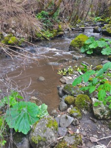
Whites Gulch
Whites Gulch is a tributary to the North Fork Salmon. It is critical cold water refugia and spawning habitat for juvenile and adult Coho salmon, spring and fall Chinook salmon and steelhead trout. Whites Gulch watershed contains Critical Habitat for Coho salmon and the Northern spotted owl. This watershed is also home to one of the four Northern goshawks nest areas that would have a high risk of abandonment because of the Westside clearcutting units.
The outer ridges were used extensively for fire suppression operations during the 2014 fires and the road system, with its many sediment sources, also saw a large amount of traffic from heavy trucks.
In October 2008, the Salmon River Restoration Council, in cooperation with the California Department of Fish and Game and NOAA Open Rivers Initiative, removed two dams from the upstream reaches of Whites Gulch. Both of the dams were remnants of the historic mining activity that had occurred within the watershed. The removal of the dams and the subsequent removal of the culvert barrier on Whites Gulch Road, restored access to 3.5 miles of refugia, rearing and spawning habitat in Whites Gulch.

Grider Creek/ No Name Creek (Grider Tributary)
Upper Grider Creek watershed contains one of the most important roadless areas, which provides a vital north to south wildlife corridor that connects the Marble Mountain Wilderness with the Siskiyou Crest and Red Buttes Wilderness. The entire watershed contains the largest expanse of geologically unstable areas of the Klamath National Forest and is where the highest concentration of clearcut units in the Westside project are proposed.
Grider Creek is a key watershed, meaning that it contains crucial for salmon survival. It provides spawning, rearing, and holding habitat for Steelhead, Coho, and Chinook salmon. In fact, the mouth of Grider Creek used to provide one of the largest and most important cold water refuge areas on the Klamath River. Unfortunately, the storm of 1997 raised water temperatures in this area and degraded its function as a cold refuge.
It is eligible for designation as a Wild and Scenic River recognized for its undisturbed old growth mixed conifer forests, high water quality and for wildlife because bald eagles and peregrine falcons nest there. These eagles would have a high risk of abandoning their nest areas because the Westside project would decimate the area.
While Grider Creek still has large areas with minimal human activity, it is clear that managed areas of the creek are being degraded. Areas that previously provided the connectivity necessary for the wellbeing of many sensitive species in the area have turned into patchy forests unusable by many animals. If human activity increases throughout this pristine area, habitats will quickly diminish and already threatened species will suffer.
Walker Creek
Walker Creek provides high quality water to the Middle Klamath River and acts as a thermal refuge for anadromous salmonids during warm months. Additionally, Walker Creek provides spawning, rearing, and holding habitat for fall and spring-run Chinook salmon, winter and summer-run steelhead and threatened Coho salmon.
The Walker Creek area contains many large, active earthflow landslides and with Grider, contains the largest expanse of geologically unstable areas of the Klamath National Forest and is where the highest concentration of clearcut units in the Westside project are proposed. This along with strong seasonal storms makes this creek particularly susceptible to large amounts of sedimentation. Past management of this area has not been successful in combating this unique feature, and has made stream sedimentation worse. These high levels of sedimentation can have devastating effects on sensitive aquatic species, and therefore must be properly controlled in order for the creek and the surrounding habitat to thrive.

Elk Creek
The Elk Creek watershed is 60,780 acres of steep slopes and large dispersed benches. It is the municipal water supply for the town of Happy Camp. This watershed provides 51.6 miles of habitat for Steelhead, Coho, and Chinook salmon, Pacific lamprey, Klamath small-scale sucker, and other native fish species. In fact, Elk Creek provides one of highest quality spawning and rearing habitats for Coho salmon in the Middle Klamath River. Its low water temperature also makes Elk Creek an important thermal refuge for many aquatic species during warm periods.
In addition to aquatic species, this watershed is home to many threatened, endangered, and sensitive species listed under the Endangered Species Act. These species include Northern spotted owls, marbled murrelets, bald eagles, and peregrine falcons. Other sensitive species include goshawks, willow flycatchers, fishers, western pond turtles, great grey owls, and martens.
Elk Creek is eligible for designation as a Wild and Scenic River and is recognized for its fisheres, geologic and wildlife values because the Siskiyou Mountains Salamander has been found there.
Logging and road building activities throughout the watershed have disturbed habitat crucial to the survival of both aquatic and terrestrial species. For example, 9,833 acres of Elk Creek watershed have experienced harvest activity over the last 40 years, 7,445 of which were clear cuts or other types of regeneration harvest.
This, along with other activities has caused the creek to exceed the Mass Wasting threshold of concern, which indicates an increased risk for hillslope sediment production. It has also led this important thermal refuge to range from “properly functioning” to “at risk” for proper stream temperatures. Once a cool water safe haven for aquatic species, increased water temperatures throughout this creek may lead to increased wildlife mortality. And while storm events and landslides are natural disturbances throughout this watershed, road building, timber harvesting, and other human activities have made it so storm events have much higher impacts on downstream aquatic resources than they naturally would.
The current goals for the Elk Creek watershed include maintaining and restoring the following: spatial and temporal connectivity, physical integrity of the aquatic system, water quality necessary to support healthy ecosystems, and sediment regimes in which aquatic systems evolved. In order to meet these goals and protect important wildlife throughout Elk Creek, it is critical that human activity is kept to a minimum.

Beaver Creek

The Beaver Creek watershed is checkerboarded with forests used as industrial timberlands. Extreme logging has taken place since the 2014 fires. Logging operations were still active up to the time of these recent storms. The Klamath National Forest has had the sense to cancel commercial logging in the watershed in the Westside project.
Beaver Creek is an important tributary to the Klamath River. This watershed makes up approximately 70,000 acres of steep sloped habitat dominated by mixed conifer and true fir forests. Beaver Creek is home to several sensitive species such as Northern spotted owls (threatened under the Endangered Species Act (ESA), northern goshawks, martens, fishers, willow flycatchers, Siskiyou mountain salamanders, and great grey owls. Additionally, Steelhead, Coho, and Chinook salmon are dependent on Beaver Creek habitat for spawning, rearing, and holding for adult and juvenile fish. Due to its ecological importance, this watershed includes designated Special Interest Areas, and Late-Seral Reserve land allocation areas. These areas provide important habitat for sensitive species, and help protect the integrity of this rich watershed.
Over the years the quality of the Beaver Creek has been greatly degraded. Roads, mainly created to access timber harvest areas, are the current largest impact on the drainage. Approximately 440 miles of roads and an unknown amount of skid trails now occur within the drainage. These roads, as well as timber harvesting, has negatively impacted the watershed and degraded high quality habitat in many ways. Accelerated erosion associated with roads and logging leads to extremely high levels of stream sedimentation, which in turn results in loss of aquatic habitat for many species. In fact, Beaver Creek is on the 303(d) Clean Water Act list as impaired for sediment, and it has been reported that the likelihood of aquatic habitat being damaged due to debris is likely, and may influence the surrounding habitat for as long as ten years.
Roads and timber harvest also decrease connectivity and makes it more difficult for wildlife to easily move across the landscape. Connectivity is extremely fragmented but important for many species in this area, such as the spotted owl. There are 20 known spotted owl activity centers distributed throughout the Beaver Creek watershed. Without sufficient connectivity throughout the landscape, these owls and other late-seral dependent species are at an increased risk of endangerment.


Comments