

Update on Last Chance Grade: Winter 2021
- Tom Wheeler

- Mar 9, 2021
- 5 min read
Updated: Jul 23, 2021

The Redwood Highway, also known as Highway 101, is the main north-south arterial connection for North Coast residents and visitors alike. “Last Chance Grade” is a stretch of Highway 101 about ten miles south of Crescent City, which sits precariously above the Pacific Ocean. Built on an active landslide, the road has steadily slipped towards the Pacific Ocean. Most recently, landslides have resulted in the temporary closure of the road and significant delays as Caltrans works day and night to safely repair damages and to keep the road safe. This pattern–of regular landslides and land closures, patched together with stop-gap fixes–is far from ideal. Instead of extending this period into perpetuity, Caltrans wants to figure out a more permanent solution.
Figuring out that permanent solution is tricky. Last Chance Grade is surrounded on either side by Redwood National and State Park land, including a magisterial stand of old-growth redwoods. Further to the east are industrial timberlands owned by Green Diamond Resource Company, although a bypass through this area would necessitate crossing back through those old-growth redwoods. Through all areas are steep slopes and an extremely erosive soil prone to sliding.
The recent closures have caused many of you to write to EPIC to ask about the various alternatives, timelines, and our feelings on the project’s progression.

Caltrans began its analysis by examining 11 potential alternatives. Today, Caltrans is down to seven alternatives, cleverly named X, L, F, A1, A2, G1, G2. Below are longer descriptions of each. EPIC anticipates that Caltrans will further reduce the range of alternatives under consideration before the first formal opportunity for public comment, as lengthy consideration of each alternative adds time and money to the project. In deciding what alternatives to further evaluate, and ultimately which alternative to pursue, Caltrans will likely need to balance a range of considerations, most particularly: cost (of construction and of mitigating impacts to the environment), environmental impacts, the risk of future short-term and long-term failures, and challenges to construction. In our review of the existing alternatives, two stand out: X and F. Based on our current information, we hope that either of these alternatives becomes the “preferred” alternative.

Alternative X would be a full rebuild of 1.1 miles of highway, but unlike the other alternatives, this alternative would maintain the current alignment as much as possible. Caltrans believes that current sliding is a product of too much water in the soil, which promotes landsliding. X would rebuild the road, including digging back and armoring the slope in areas, as dewatering the route through wells and pumps to promote greater soil stability. Because this alternative would more-or-less stay in its current alignment, the ground disturbance impacts from the project are the least significant, with 10 acres of coastal shrub likely affected. The pricetag is also among the least expensive, at $300 million, and a relatively quick construction timeline at 3.5 years to complete. The downside? Caltrans is still figuring out if this alternative is technically feasible or if it would result in a significant enough improvement over the existing road to justify its construction. So far, however, Caltrans is optimistic that this will be viable. Dewatering as a form of slope stabilization has been successfully pursued in other areas of California.
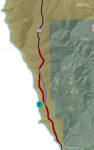
Alternative F is a BIG tunnel dug beneath the active landslide, a feat of engineering that Caltrans feels very confident is doable. As a tunnel, it would avoid most above-ground environmental impacts except for the tunnel mouth openings, which would result in some loss of mature/old-growth trees. Once built, this alternative would have a very low risk of future closures and the cost to maintain would be low. The downside? Cost. A large tunnel through Last Chance Grade won’t come cheap, likely topping one billion dollars.

Alternative L would push the road higher up the coast-facing ridge, with the idea that by moving up in elevation, the road could sit above or atop the slide area. EPIC was initially excited about Alternative L because it appeared that it could largely stay out of mature forested areas. However, further development of this alternative has found that impacts would likely be larger than initially anticipated. Caltrans is also unsure of the potential future performance of this alternative. Both are significant knocks on this alternative and we would not be surprised or disappointed if it was removed for further study.

Alternative G2, includes Coastal scrub/grassland /spruce: 22 acres, Riparian: 1 acre, Clear cut: 3 acres, Young Redwood Forest: 28 acres, Mature Redwood Forest: 3 acres, Old Growth Redwood Forest: 3 acres
Alternatives A1, A2, G1 & G2
These four alternatives are all permutations on the same general theme. Each bypass the slide area by going east–the A alternatives making a broad S-shaped curve and G barreling up and over the coastal ridge. Once east, the road would reconnect with Highway 101 in one of two ways, either through a short tunnel (A1 and G1) or through a causeway through an old-growth redwood forest. All four alternatives share certain things in common: all would require significant earthwork and all would impact old-growth forests and natural resources, although the A alternatives generally perform better than the G alternatives in both respects.
Admittedly, these alternatives have made EPIC nervous in the past. The old-growth stand where both the tunnel and causeway would reconnect with Highway 101 are superlative and surprisingly wild, given their location near the highway, with evidence of marbled murrelet, bears, and elk. (See EPIC’s groundtruthing of A2 from 2018 here.)
Like Alternative L, EPIC would not be surprised or disappointed if these alternatives were removed for further study. The cost, both in time and money, to further study these alternatives is likely unnecessary, given that X and F appear to outperform these alternatives in nearly every metric conceivable.

Caltrans anticipates that a new alternative will not open until 2039. 18 years is a long time. Avoiding impactful and controversial alternatives is one way that Caltrans can both cut time from the project and reduce the likelihood of litigation that can stop or slow a future project. By reducing the range of alternatives to remove more-impactful alternatives, Caltrans can save on timely and costly studies. (The more impactful of an alternative, the more studies are demanded to document the likely impacts and ways to mitigate these impacts.) The risk of litigation is likely related to the choice of alternatives as well, with more impactful alternatives increasing the odds that some group or some individual attempts to delay or kill the project in court.
Thankfully, Caltrans has taken the right steps to eliminate some early impactful alternatives and to engage major stakeholders, including EPIC. Through engagement with nearby landowners, Caltrans has been able to more expeditiously receive permission to do geotechnical analysis to determine alternative feasibility. Stakeholder engagement also works to relieve tension among groups with potentially competing interests and by early consideration of issues raised by stakeholders that may have otherwise escaped attention. In this, we can see a “new” Caltrans emerging. EPIC can only imagine that if a similar stakeholder engagement had occurred for Richardson Grove or any other court-bound project, that it might have been possible to avoid a protracted fight.


Comments